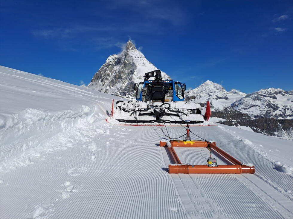
This is how glacier thickness is measured today
The pylons of the gondola and chairlift infrastructure are anchored in thick glacier ice, but the glaciers are melting under climate change. They are sinking and shifting, and the pylons are shifting with them. To ensure that the lifts and slopes remain operational and functional, the ski resort needs to obtain precise measurements of the ice thickness at various points on the glacier. Only with these measurements can they secure the future of the ski area and plan projects for decades to come. This is exactly where GEOTEST AG comes into play.

The pylons, which are fixed to the glacier ice, are shifting due to the movements and melting of the glacier.
In mid-May, two of our employees set out on skis, accompanied by a snow groomer, to make their way across the glaciers in the southern part of the ski resort. They travelled across the glacier while using ground-penetrating radar to continuously measure the thickness of the ice down to the bedrock.
This is what the measurement looks like on the glacier.
The advantage of this radar method is that measurements can be made quickly and easily. The device can be pulled along defined measurement profiles by a snow groomer, and it only requires partial guidance by measurement technology specialists.

The radar device, with its two antennae, is mounted on the sledge and transmits radiation directly through the glacier ice beneath the snow. The GPS records the exact position once per second during the measurements.
The transmitter antenna of the ground-penetrating radar sends electromagnetic radiation through the snow and ice layers of the glacier. This signal is reflected at the bedrock and from objects in the ice, and it is then registered again at the radar device by the receiver antenna.

1. With ground-penetrating radar, measurement signals are continuously transmitted and received while the device is moving. 2. A radargram is created from the recorded signals: the x-axis shows the position along the measurement profile and the y-axis shows the calculated depth, based on the transit time and propagation speed of the radar waves. 3. The signal strengths are displayed in various colours.
Some of the measurements were even taken 15 metres below the glacier surface, in the so-called ‘Glacier Palace’ next to the Klein Matterhorn.

In the ‘Glacier Palace’, GEOTEST employees work with a manually operated radar device.
The ground-penetrating radar captures numerous data points along the route in real time, with minimal contact and in a completely non-destructive manner. The method delivers accurate and reliable results immediately.

The ground-penetrating radar is a modern device with a wide range of applications.

The raw measurement data can be read from a screen directly on site.
Over four days, the GEOTEST measurement technician and geophysicist used the radar to cover various routes, totalling around 21 kilometres. The experienced geophysicist can identify the relevant reflectors from the raw data. He then uses the measured data to create maps of the respective ice thickness.
GEOTEST engineering geology staff are currently evaluating the maps and developing interpretations based on them. These results are an indispensable basis for understanding the current state of glacier thickness in sensitive areas of the ski resort and for precise simulations of glacier retreat. They thus provide a valuable foundation for sustainably safeguarding the operation, maintenance and expansion of alpine infrastructure.
For 45 years, GEOTEST AG has been supporting Zermatt Bergbahnen AG (ZBAG) in particularly challenging projects through its expertise in engineering geology. The results of the geophysical analysis then provide a solid data basis for our interpretation and recommendations to ZBAG.
- Pierre Dalban, Project Manager